
It is a complete, large scale map of the Kingdom of Galicia and Lodomeria, which was in preparation since 1775 and was completed in the years 1779–1783 by the efforts of the Austrian Staff of the General Quartermaster. In the Polish literature it is customarily called the “Mieg map”, after the name of the Staff officer who lead the majority of works, Friedrich von Mieg. Initially kept secret, due to its military significance, it was never edited and remains in the manuscript to the present day.
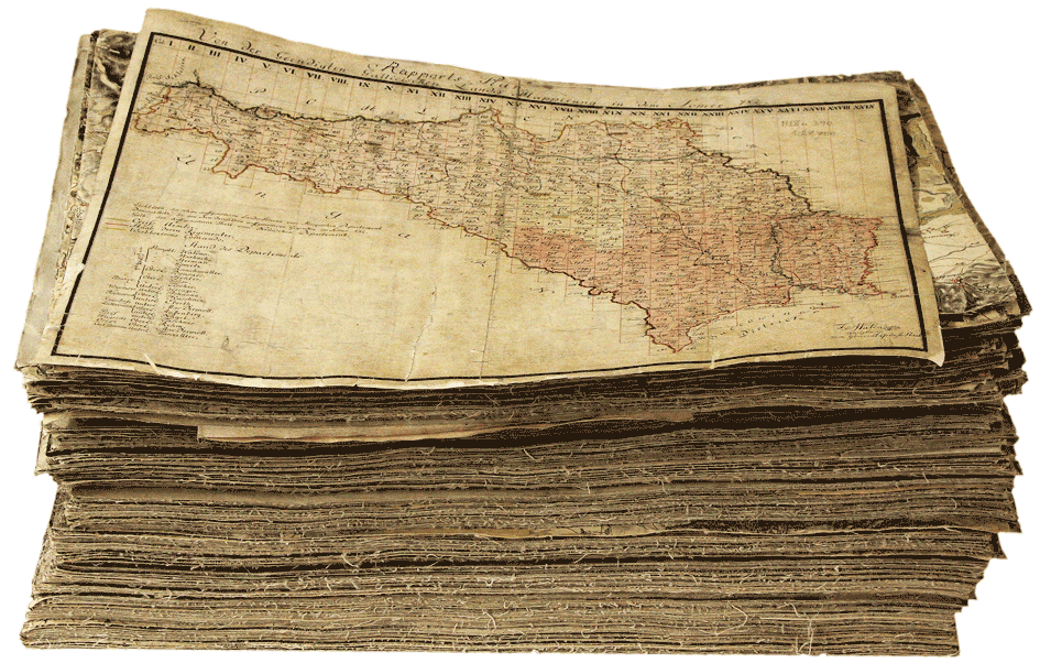
It consists of 413 large scale sheets (basic size: 24×16 inches, i. e. ca. 63×42 cm) and of several dozen additional sheets with a total surface of ca. 115 square meters. It is preserved in three full copies (the original, the fair drafting or the first copy, the second copy). The map is generally in a good condition, but here and there we find sheets more heavily worn.
The map was created as a part of the so called Josephine land survey, a great cartographic project which included lands under the Habsburg rule.
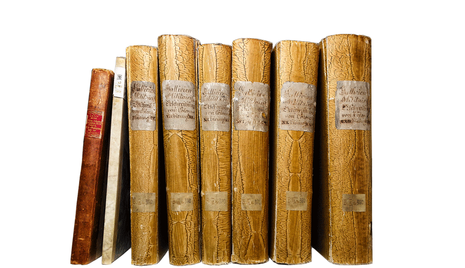
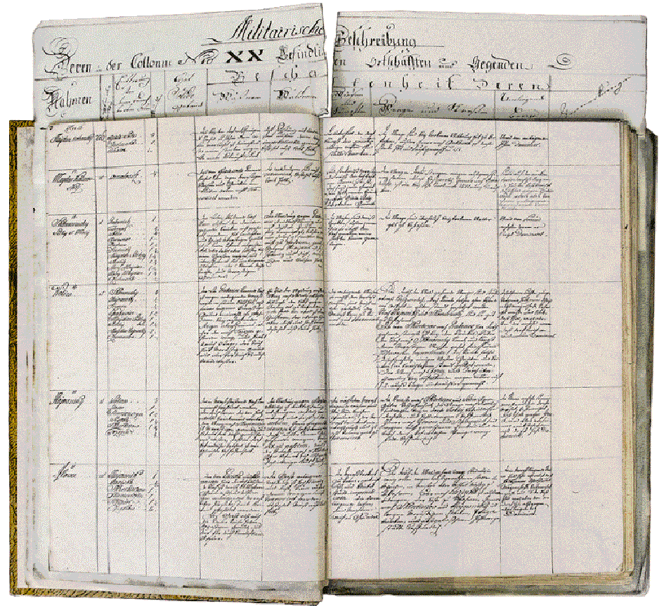
The map is accompanied by six volumes in folio containing landscape descriptions and a commentary which complements the situation depicted on each particular sheet of the map. It is also supplemented by a volume containing the topometric calculations and a list of places with a separate list of name corrections. Volumes containing descriptions are well preserved.
Josef Paldus, Die Einverleibung Galiziens und der Bukowina in die österreichische Monarchie im Jahre 1772, in:
„Mitteilungen der k. k. Geographischen Gesellschaft in Wien”, vol. 59, no. 7, 1916, p. 417–455
open
Andrzej Konias, Kartografia topograficzna Śląska Cieszyńskiego i zaboru austriackiego od II połowy XVIII w. do początku XX w. [Topographic cartography of Cieszyn Silesia and the Austrian section of partitioned Poland from the second half of the 18th century to the beginnings of the 20th century], Katowice 2000
Waldemar Bukowski, Andrzej Janeczek, Mapa józefińska Galicji (1779–1783) w przededniu edycji.
Przedmiot i założenia programu wydawniczego [Josephine map of Galicia (1779–1783) on the eve of the edition. The subject and assumptions of the publishing plan], in: „Studia Geohistorica. Rocznik Historyczno-Geograficzny”, vol. 1, 2013, p. 91–112
open open
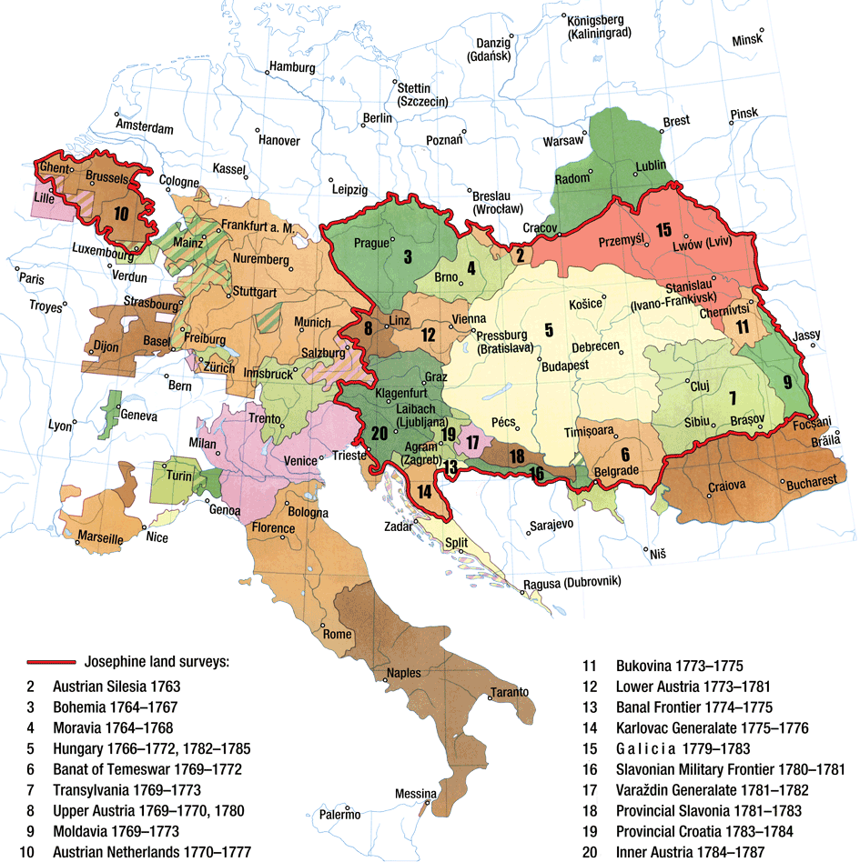
The map of Galicia constitutes a part of a big effort to map vast areas of Europe within the so called Josephine land survey. The idea to survey all lands under the Habsburg rule was born after the experience of the Seven Years’ War (1756–1763), when the generals of the Austrian army, after their operational defeats in Silesia, came to the conclusion that field maps of much better quality than hitherto were indispensable. The empress Maria Theresa ordered the execution of a thorough survey of the entire monarchy. The task was delegated to the Staff of the General Quartermaster. The works started in the Austrian Silesia: during the years 1763–1764 maps of Cieszyn, Opava and Nysa principalities were created. Since 1765 the assignment was supervised by Joseph II, who was admitted to co-governance.
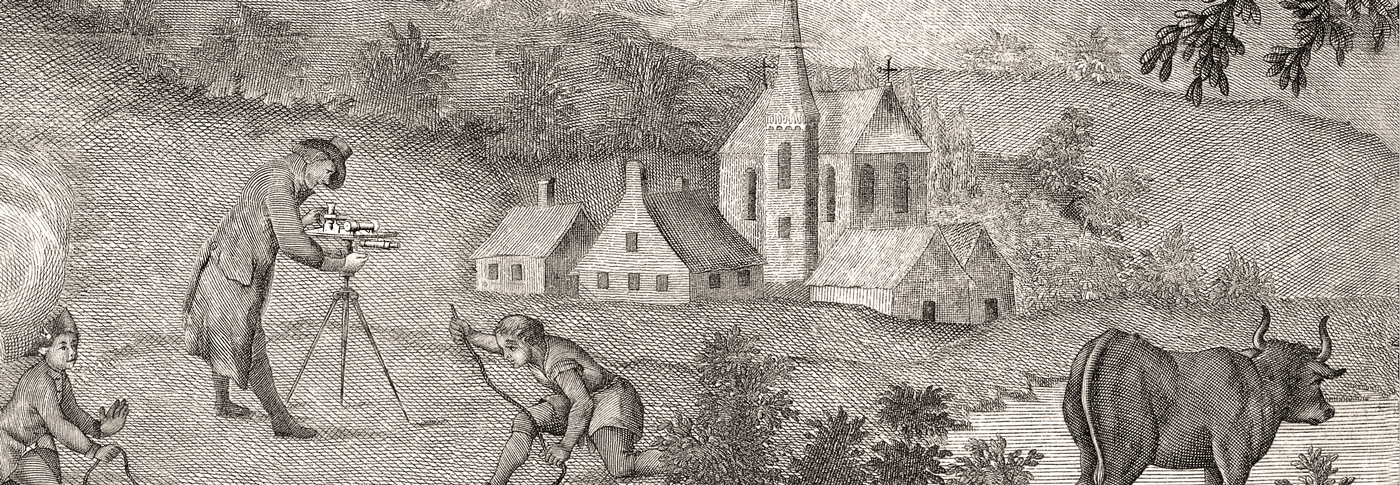
Adopted were uniform rules of mapping: at a scale of 1 : 28 800 (1 inch on a map = 1000 steps, that is 400 Viennese fathoms in the field), basing on field measurements, by using triangulation but also the à la vue method („by eye”), by using a table, alidade, a compass, an astrolabe and a quadrant. Until 1787 mapped on over 3500 sheets sized 24×16 inches was the majority of the monarchic lands. All the material became deeply confidential.
The engagement of the state in the cartographic works and entrusting them to a military institution gave excellent results. Ably and in a short time, using methods that were modern in those days, drawn were large scale maps of a vast territory measuring 570 thousand square km, which encompassed the area of Central Europe and large parts of Eastern, Southern and Western Europe. The scope of the Josephine land survey is depicted by the following map.
After the Josephine land survey was finished the works were continued, i. a. on the newly annexed territories. In 1806 began the second military mapping of the monarchy lands (during the rule of Franz II) at the same scale 1 : 28 . It lasted until 1862, whereas in 1869 began the works on the third, Francis-Josephine mapping, implemented though in already different metric scales: 1 : 25 000 and 1 : 75 000.
Due to the importance of the Josephine maps as monuments of the European cartography and a valuable historical source material, a demand has been declared in many lands for publishing these manuscripts in the form of facsimiles of maps and a critical edition of the descriptive part.
In the sixties of the 20th century began the publishing of a multi-volume edition of the map of the Austrian Low Countries (Carte de Cabinet de Pays-Bas autrichiens levée à l'initiative du comte de Ferraris, 12 volumes of maps, 12 volumes of descriptions, Bruxelles 1965–1974; new edition, cf. De grote atlas van Ferraris: de eerste atlas van België: Kabinetskaart van de Oostenrijkse Nederlanden en het Prinsbisdom Luik, 1777. Le grand atlas de Ferraris: le premier atlas de la Belgique: carte de Cabinet des Pays-Bas autrichiens et de la Principauté de Liège, 1777, ed. Wouter Bracke, Brussel 2009, 2011).
Since the 90s of the 20th century, big editorial initiatives started in Slovenia and Croatia, all under the aegis of the government and the national agencies of the academies of sciences, also in Hungary and Italy. Currently completed is the facsimile edition of the Josephine map of Slovenia (Slovenija na vojaškem zemljevidu 1763–1787 | Josephinische Landesaufnahme 1763–1787 für das Gebiet der Republik Slowenien, ed. Vincenc Rajšp [et al.], vol. 1–7, Ljubljana 1995–2001), advanced are the works on the Croatian project (Hrvatska na tajnim zemljovidima 18. i 19. stoljeća, ed. Mirko Valentić [et al.], planned are 20 volumes, presently ready are 12 volumes, Zagreb 1999–2009), printed is also the map of the Duchy of Venetia (Kriegskarte 1798–1805: il Ducato di Venezia nella carta di Anton von Zach | Das Herzogtum Venedig auf der Karte Antons von Zach, ed. Massimo Rossi, vol. 1‒3, Treviso 2005).
Moreover, apart from the complete editions, several selected sheets were published in Slovenia, together with descriptions: Bohuš Klein, Významné mestá Slovenska na tajných mapách 18. storočia, Bratislava 2003. The map of the present territory of Slovakia is nevertheless contained in the Hungarian edition. Presented in Ukraine were only small fragments, in a quality worse than the original: Halyna P. Petryšyn, Karta F. fon Miga (1779–1782 rr.) jak džerelo do mistoznavstva Halyčyny, Lʹviv 2006.
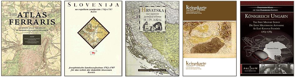
Realized in a different way, namely by the digital method, was the Hungarian edition of the Josephine map of the Kingdom of Hungary (Az első katonai felmérés – Magyar Királyság | Die Josephinische Aufnahme. Die erste militärische Vermessung: Königtum Ungarn, Budapest 2004, 2006) also of Transylvania and Banat (Az első katonai felmérés – Erdély és a Temesi Bánság | Die erste militärische Vermessung: Siebenbürgen und das Banat von Temes, Budapest 2005, 2007); the editions have the form of DVDs. The Josephine map of Czechia, Moravia and a part of Silesia was published in the Internet on the webpage of the Jan Evangelista Purkyně University, together with other cartographic materials. Made similarly accessible – via Internet – was the Josephine map of Styria. The latter is available within the full cartographic service of the land (Geographic Information System) as Digitaler Atlas Steiermark. A comparable service is provided in Tirol. The map of the Low Countries, apart from the regular “paper” edition, was also published in the Internet.
The entirety of maps included in the Josephine land survey (the accompanying descriptions excluded) is being newly presented on the portal Mapire (Historical Maps of the Habsburg Empire), together with the maps of the 2nd and 3rd survey and other cartographic materials.
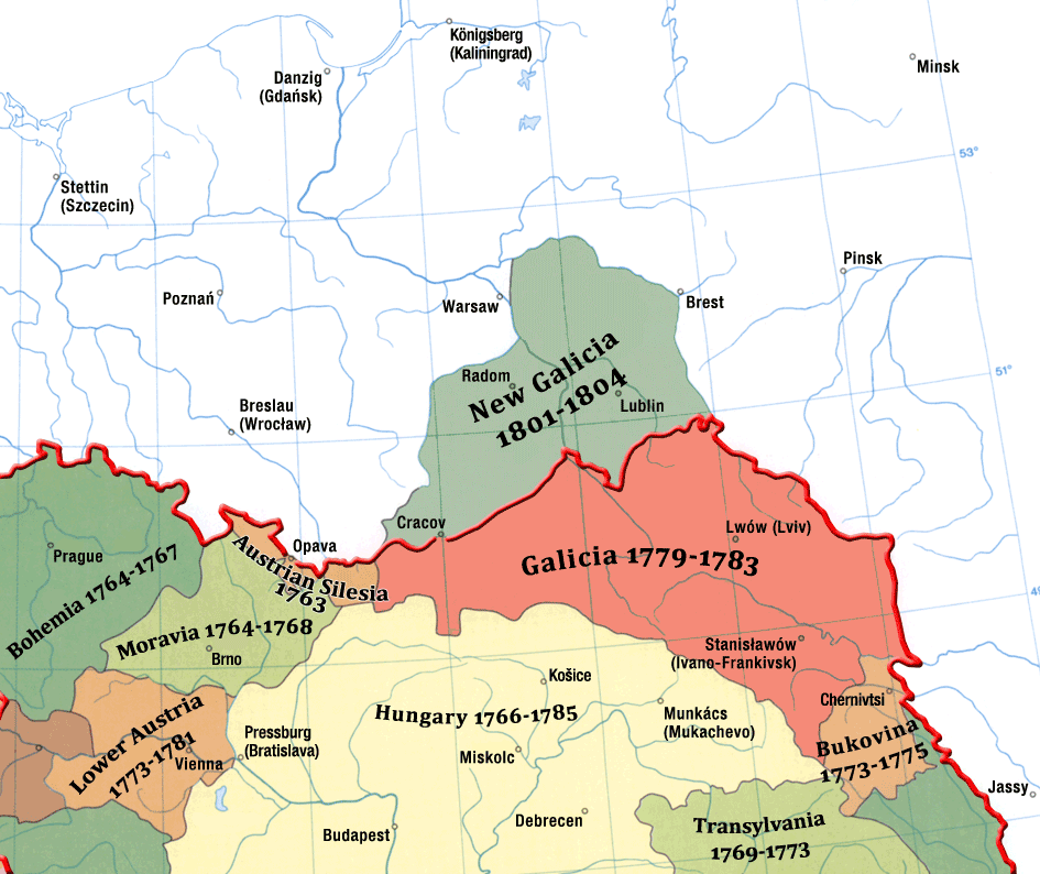
The map covers territories belonging to two Old Polish regions (Lesser Poland and Red Ruthenia) which fell within the scope of the old Cracow and the Sandomierz Voivodeship, Ruthenian and Bełz voievodships, as well as fragments of the Volhynia and Podolia. These are the territories of the Polish Commonwealth incorporated into Austria as a result of the events of 1770 (annexation of the Nowy Targ, Czorsztyn and Sącz captains), as well as lands expropriated in the course of the first partition of Poland in 1772 (Spisz captain excluded). These territories were formed into a new land of the Crown and given the name of the Kingdom of Galicia and Lodomeria. The Kingdom extended to the north from the culmination of the Carpathian arch, and from the springs of the Vistula River in the west to the Zbrucz River in the east. During the years when the map was compiled also Zamość land belonged to the Kingdom. It became separated in 1809.
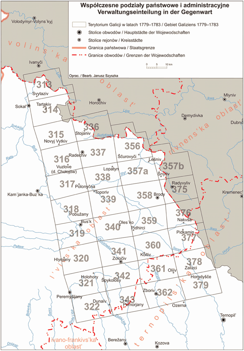
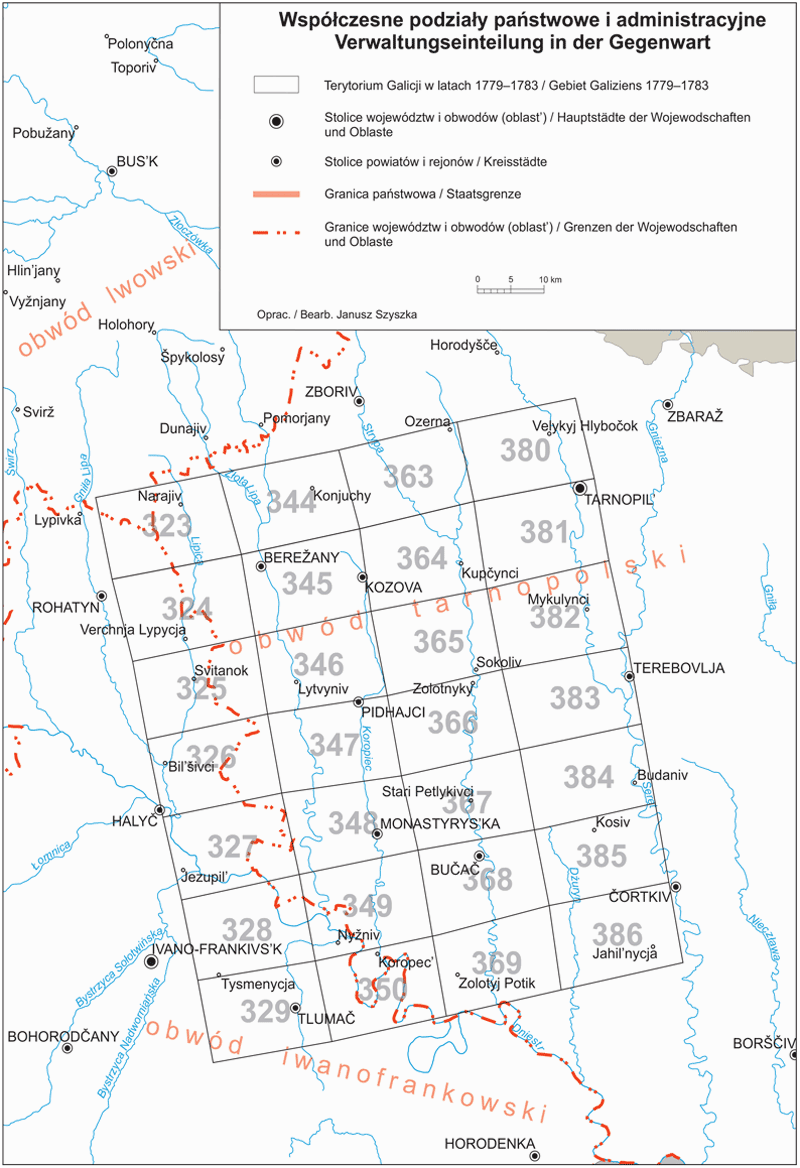
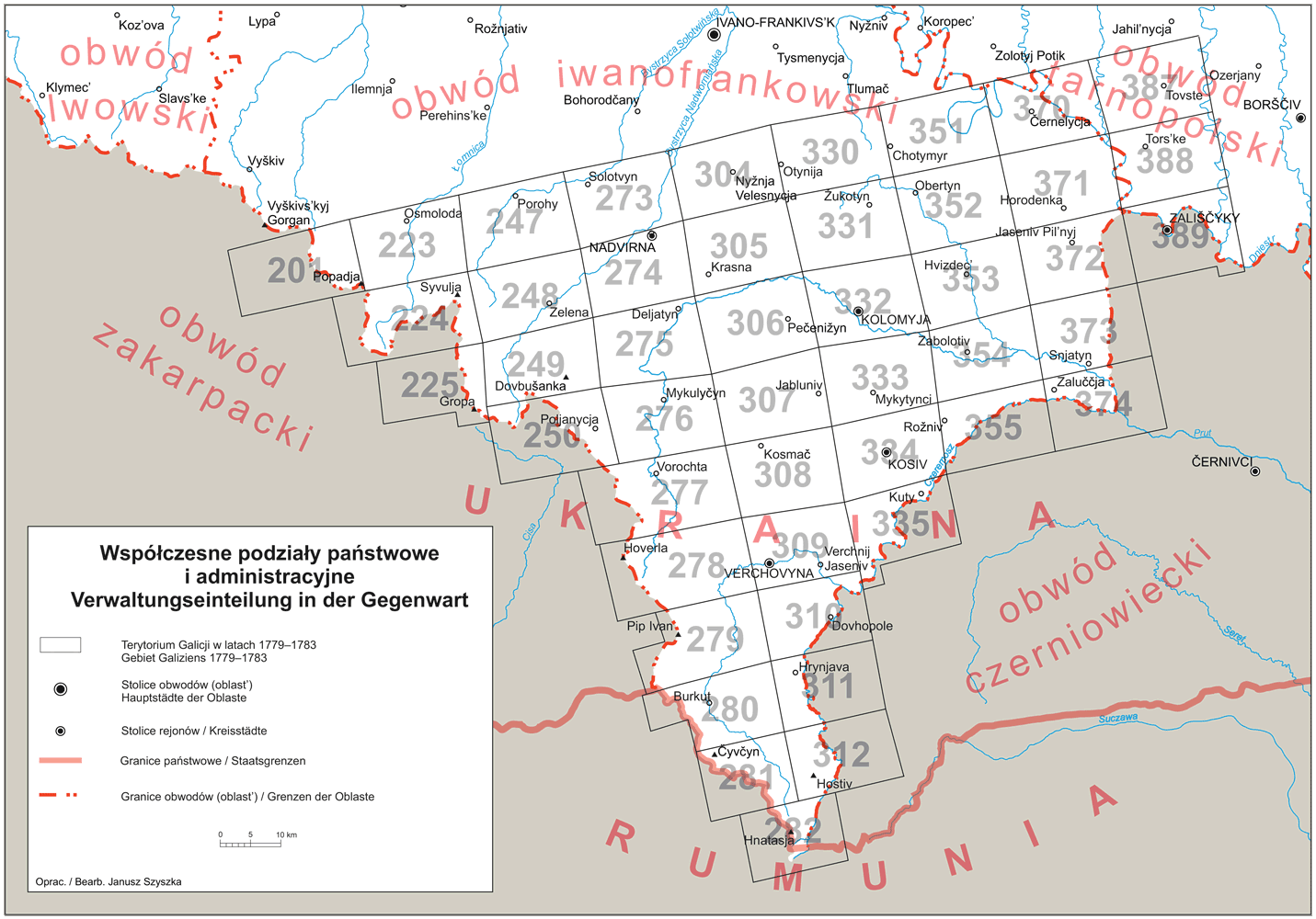
Since Poland restored its independence in 1918 the area captured on the Josephine map of Galicia was a part of the following voivodeships: Cracow, Lublin, Lwów, Tarnopol and Stanisławów. Presently, after the post-war shifts of the borders, it belongs to Poland (voivodeships: Silesian, Lesser Polish, Subcarpathian and Lublin – 186 sheets) and Ukraine (oblasts/districts: Lviv, Ternopil, Ivano-Frankivsk – 227 sheets).
The 3rd zone of the Austrian Partition (1795), the so called West (New) Galicia, was also mapped before Austria lost these territories to the Duchy of Warsaw (1809), later the Polish Kingdom under the Russian rule. The map, prepared in the years 1801–1804 under the responsibility of Colonel Anton Mayer von Heldensfeld, does not belong to the series of the Josephine maps, but is considered its aftermath due to the use of similar methods and the same scale. It is kept in the War Archives in Vienna. Preparations for the edition of this map have started in 2019.
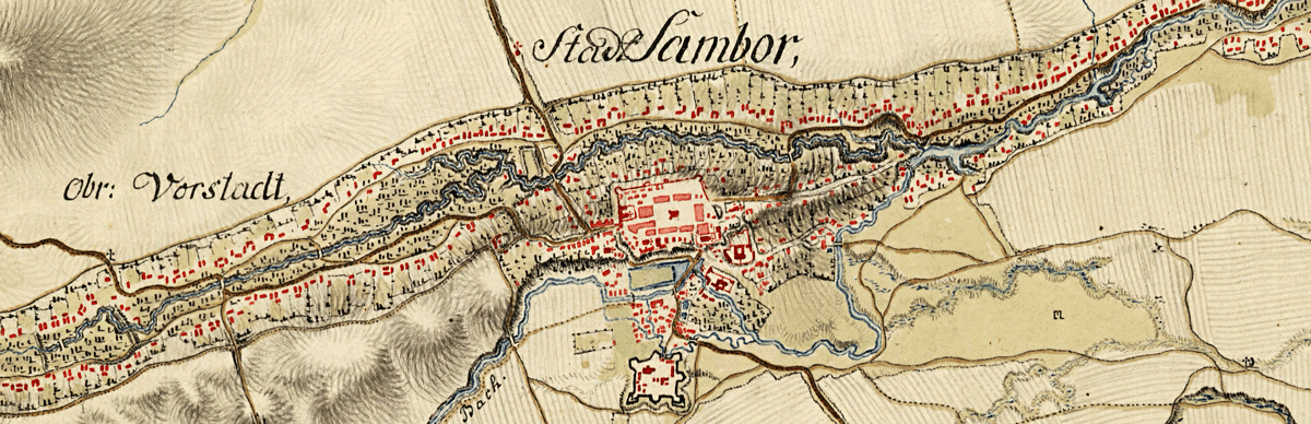
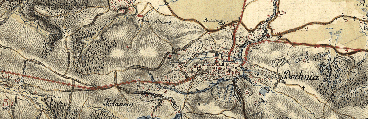
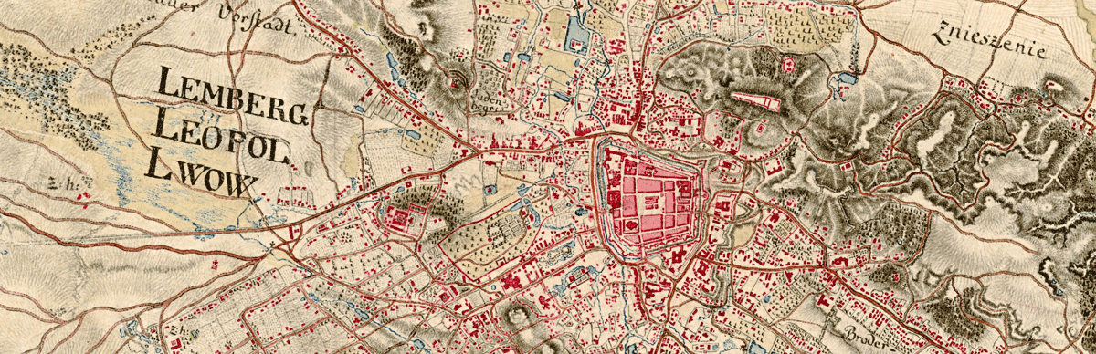
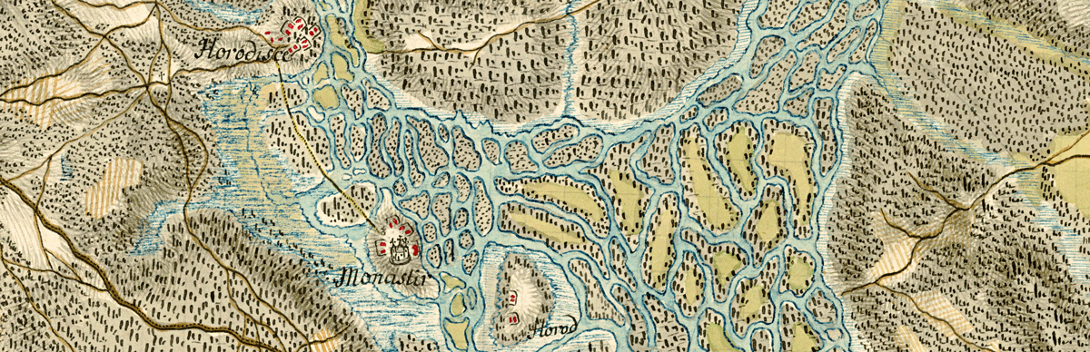
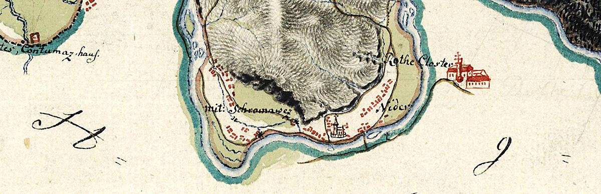
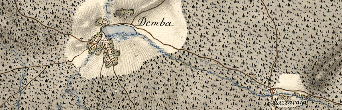
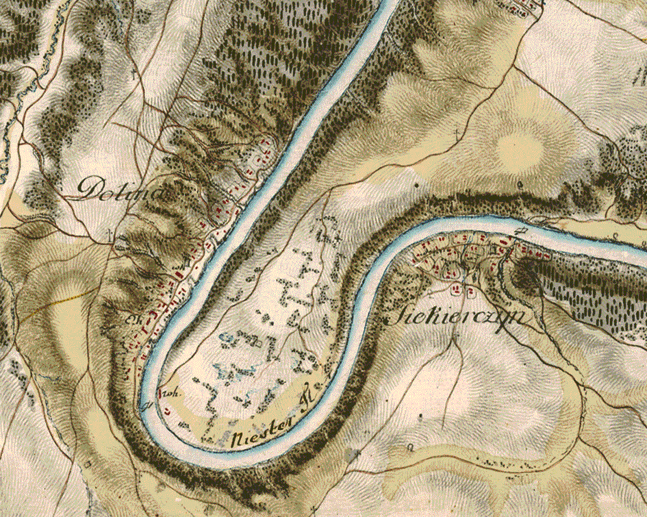
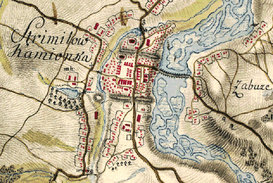
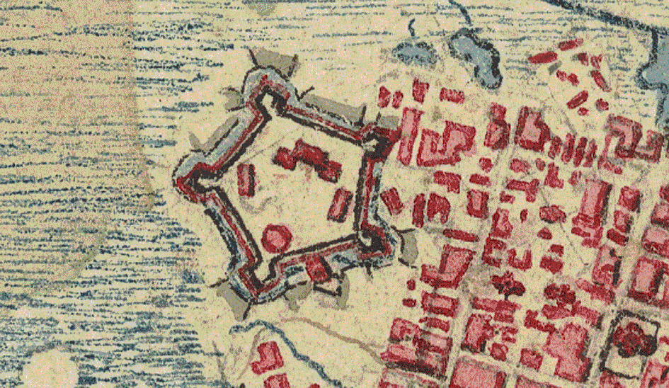
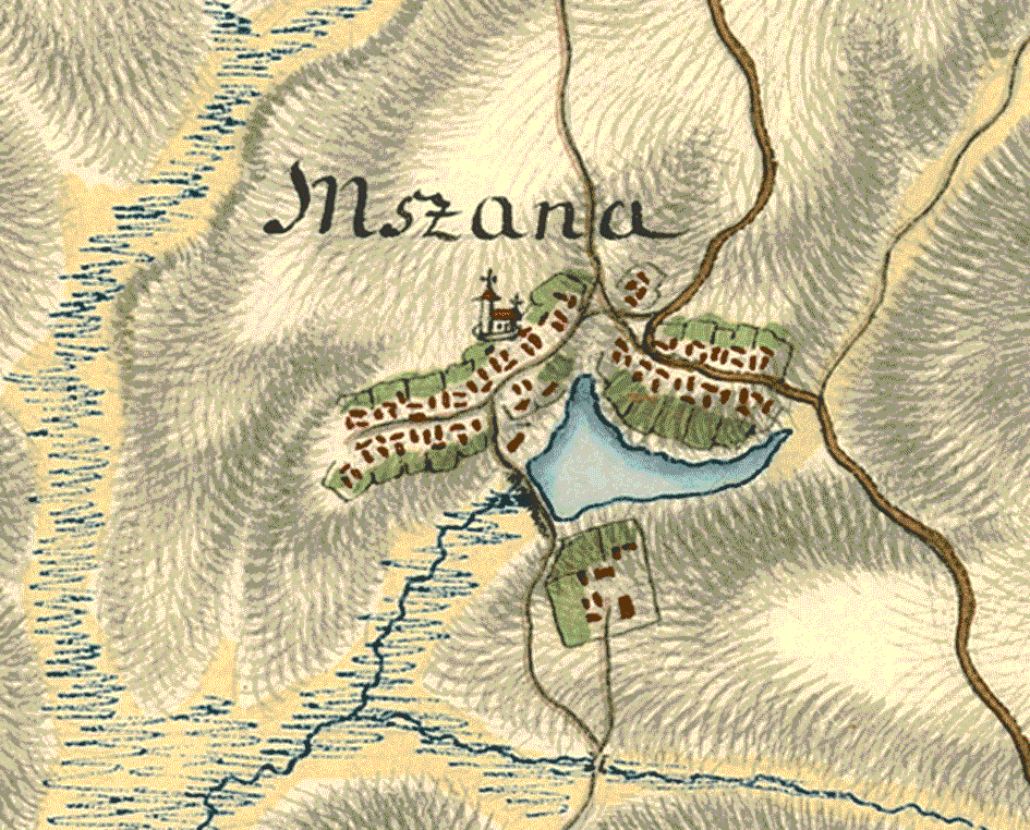
The map reflects the relief by the cross-hatch method (mountains, elevations, brinks of the river valleys, steep and smooth river banks, high banks of the water reservoirs, stream valleys, ravines, canyons, all sorts of hills, embankments, dykes, dunes), features elements of hydrography (rivers, streams, old river beds, river islands, lakes and ponds, marshlands), fields and meadows (with distinction between those overgrown with bushes and the wetlands), forests (the swampy forests separately), road network (tracks and postal roads, cart tracks, dirt ways and forest paths, passages through the swamps, walking and riding paths, stone and wooden bridges, fords and ferries), settlement network (housing, streets, city walls, churches, town halls, homesteads, manor houses, granges). It considers castles and fortresses, economic facilities (mills, sawmills, salt mines, shafts), inns and hostelries, roadside crosses and shrines, Jewish cemeteries. It draws the state border and designates pairs of border posts. It abundantly registers the names (of settlements and hamlets, rivers and streams, mountain peaks etc.), usually capturing them phonetically and sometimes distorted (written down from hearing by an Austrian officer not accustomed to the Polish or Ukrainian speech).
Descriptions, which are a textual commentary to the geographic contents of the map sheets, bring additional information: they provide the characteristics of particular places, their location, their defensive possibilities. Listed are „solid”, i. e. masonry buildings (usually churches, monasteries, castles, palaces and fortifications), assessed are the accommodation options, discussed is the state and the kind of forestry and meadows, pastures and marshes, the hydrographic situation, access to drinking water. Pictured is the state of roads and ferries under various weather conditions, assessed their practicability, often with instructions on how to mend a cumbersome stretch of a route or a bad bridge. Finally, described are the features of the local landscape: usually mentioned are mountains and hills, in particular the dominating ones, which could had been useful as observation points or landmarks or for firing positions. Sometimes the descriptions are accompanied by observations and recommendations on how to use the local field conditions in tactical actions.
The map of Galicia was created in the last moment before the coming of the great economic and social changes of the 19th century: the industrialization, the capitalistic urbanization, the reform of the agrarian relations. The map registers the picture of the countryside on the threshold of the Josephine colonization and its following transformations; of the cities on the threshold of the redevelopment (the removal of walls and ramparts, the implementation of the sanitary regulations) and before the introduction of the spatial regulations; of the highroads before the creation of the paved roads (beside them it depicts the just planned sections of the first imperial highways); of the forests before the mass felling, of the rivers and streams before the moving of their courses and the meliorations. Its exactness and the time of the registration make it to a great source material, the only one giving insight into the landscape of the still Old Polish era on the area of the entire region.
The map reflects the state from the beginning of the period of partitions, already under the rule of a foreign power, but still before the profound economic and social changes which transformed the Old Polish landscape and covered up its features. By providing such detailed material it serves as a convenient starting point for the reconstruction of the natural conditions and the picture of the settlement and the development of the lands of the Commonwealth, inclusive of an attempt of retrogression up to the Middle Ages. If we channel the observations in the opposite direction the map may also serve as an initial basis for the references in the studies on the changes which the 19th century has introduced through the industrialization, the development of the cities, the abolition of serfdom and other reforms of the rural system, great engineering works or the exploitation of the forests and the natural resources.
The Josephine map o Galicia, secretive and unknown from the beginning (the existence of the descriptions was made public as late as 1864), was for a long time available only to a narrow circle of people authorized by the emperor. The first public presentation which definitely broke the time of its concealment took place at the world exhibition in Vienna in 1873. An early example (at the turn of the 19th and 20th century) of using the map in scientific research (and at the same time in a lawsuit) are the works of a Lwów historian Aleksander Czołowski (1865–1944) and Oswald Balzer (1858–1933): the research was prepared in connection with the border conflict over the Morskie Oko Lake, which flared up harder since 1890 between Galicia and Hungary.
The map received its first monographic study due to the research of Josef Paldus (1863–1937), a colonel of the Austro-Hungarian army, who was the leader of the Cartography Department of the War Archives during the years of the 1st World War and later a Czech representative at these Archives. Concurrently, in the years 1919–1920, active in the Vienna Archives was Ludomir Sawicki (1884–1928), professor of geography at the Jagiellonian University. He ran extensive queries on behalf of the Polish Liquidation Committee, which was to assess under the treaty of St. Germain the Polish claims regarding the restitution of the cultural and scientific goods from the former Austro-Hungarian monarchy. At that time L. Sawicki made a list of maps regarding the Polish lands and placed the information on this particular map in a catalogue published in 1920.
The map was not covered by the recovery action but the knowledge on its importance and its scientific significance began to spread. Ordered was the making of black-and-white reproductions for the National Library in Warsaw, further copies were also made for the Cracow Commission of the Historical Atlas of Poland. Since that time fragments of the map began to be used in works of many fields as duplicates of a quality much inferior to the original. The descriptions remained entirely unknown.
The Josephine map is of particular usefulness for the historical research (history of settlement, urban history, historical geography, atlas works, research on road network, river crossings, mountain passes through the Carpathians), the archaeological research (terrain prospection; the map gives the old range of the floodplains, registers the remains of the historical objects which often are no longer visible on the surface today), the research on urban planning (captured are the spatial layouts of the towns), the onomastic research (it contains a huge amount of topographic and micro-topographic names, „field” names, the names of rivers and mountains), the regional studies, the local research on the past of the cities and the villages. It presents great scientific value also for other disciplines (earth sciences – morphology of the village, ecological studies, research on the changes of the natural environment; the map gives a detailed record of the hydrographic relations of that time, the oldest reliable picture of afforestation; occasionally it was used e.g. in the reconstruction of the court park complexes). As an exceptionally beautiful cartographic monument and an outstanding achievement in this field it is an object of interest for geographers and historians of cartography on itself.
The project was carried out in the years 2009–2011 within the program titled „Exterius – Poza szlakiem” [Off the Trail] of the Foundation for Polish Science. The author of the project was Andrzej Janeczek (Institute of Archaeology and Ethnology PAS, Warsaw). Obtained was the digitized archival material prepared for further stages of editorial works, equipped with editing tools (active data indexes) and an introduction bringing the primary source analysis.
On the initiative of Waldemar Bukowski and Zdzisław Noga, who were joined by Andrzej Janeczek and Zdzisław Budzyński, four parallel editorial projects were created and carried out in the years 2008–2014, under the research grants of the Ministry of Science and Higher Education and the National Science Centre. Their goal was to prepare the material for a complete critical edition of the entire Josephine map of Galicia, including the accompanying descriptions. Five institutions participated in this coordinated plan: the Institute of History of the Pedagogical University in Cracow (project leader: Zdzisław Noga), sheets 1–93; the Institute of History PAS (project leader: Waldemar Bukowski), sheets 94–201, the Institute of Archaeology and Ethnology PAS (project leader: Andrzej Janeczek), sheets 202–312; the Institute of History of the University of Rzeszów (project leader: Zdzisław Budzyński), sheets 313–413; the Polish Academy of Sciences Scientific Center in Vienna (director Bogusław Dybaś).
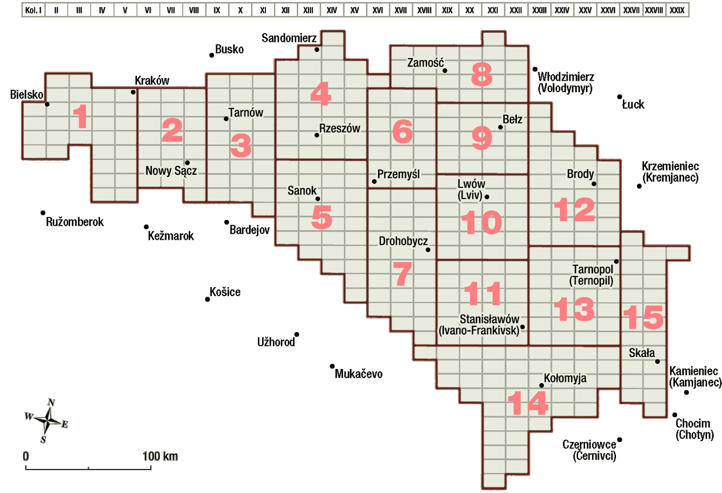
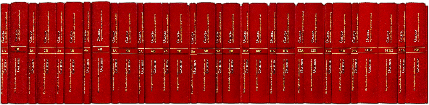
The edition has been planned in 15 volumes. The division of the source material (map sheets and descriptions) into volumes is illustrated by the index. Each volume consists of two or three books. The first one (part A) contains introduction articles, presenting the source material and the rules governing the edition as well as the reconstructed map key, furthermore – the texts of the descriptions in German with a parallel translation into Polish, commentaries to the descriptions, moreover an inventory of names on the map, in other words the so called toponymy of sections and a cumulative index of maps and descriptions. Placed in the part B are the facsimiles of the maps, counting from 20 to 46 sheets, depending on the length of the text source. The volumes embracing the territory of modern Ukraine are additionally provided with a translation of the military descriptions into the Ukrainian language (part C).
The project was carried through as a part of the National Program for the Development of the Humanities by the Institute of History of the Pedagogical University in Cracow (project leader: Zdzisław Noga), in cooperation with the Institute of History PAS (Waldemar Bukowski) and the Institute of Archaeology and Ethnology PAS in Warsaw (Andrzej Janeczek), and also with the Polish Academy of Sciences Scientific Center in Vienna (Bogusław Dybaś). It was lead in the years 2012–2016.
The project was scheduled to run from 2015 to 2022 and realized as a part of the National Program for the Development of the Humanities by the Institute of Archaeology and Ethnology PAS in Warsaw (project leader: Andrzej Janeczek), in cooperation with the Institute of History PAS (Waldemar Bukowski), Institute of History of the Pedagogical University in Cracow (Zdzisław Noga), Institute of History of the University of Rzeszów (Zdzisław Budzyński) and the Polish Academy of Sciences Scientific Center in Vienna (Bogusław Dybaś). The final volume was published in 2022; thus the edition is complete.
Following the book edition the publishers aim to prepare a digital edition which was considered and planned from the very beginning of the works on the publication. This initiative depends on obtaining a separate license from the Austrian State Archives.
Zdzisław Budzyński

Institute of History
University of Rzeszów
Aleja Tadeusza Rejtana 16c
35-959 Rzeszów
Waldemar Bukowski
Institute of History
Polish Academy of Sciences
Cracow Branch
ul. Sławkowska 17
31-016 Kraków
Bogusław Dybaś
Institute of History and Archival Sciences
Nicolaus Copernicus University
ul. Bojarskiego 1
87-100 Toruń

Andrzej Janeczek
Institute of Archaeology and Ethnology
Polish Academy of Sciences
Aleja Solidarności 105
00-140 Warszawa
Zdzisław Noga
Institute of History and Archival Studies
Pedagogical University of Cracow
ul. Podchorążych 2
30-084 Kraków
Natalia Bilous, Kiev
Oleh Dukh, Lviv
Olha Hul, Lviv
Beata Kita, Warsaw
Andrzej Konias, Słupsk
Elżbieta Kwiatkowska-Dybaś, Toruń
Irmgard Nöbauer, Vienna
Piotr Oliński, Toruń
Jerzy Ostrowski, Warsaw
Isabel Röskau-Rydel, Cracow
Andrii Stasiuk, Ivano-Frankivsk
Janusz Szyszka, Cracow
Łukasz Walczy ♰, Cracow
Ewa Wółkiewicz, Warsaw
Andrii Zhyvachivskyi, Ivano-Frankivsk
The publication of all fifteen volumes was made possible by the support of the National Program for the Development of the Humanities.
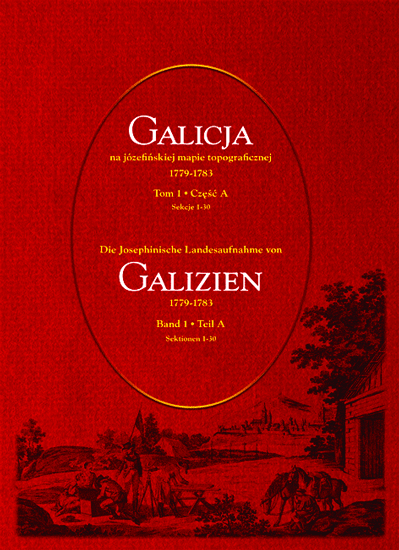
The publication is titled
Galicja na józefińskiej mapie topograficznej 1779–1783
Die Josephinische Landesaufnahme von Galizien 1779–1783
Kraków-Warszawa 2012–2022
Vols. 1, 4: Wydawnictwo Antykwa (ISBN 978-83-7271-785-2)
Vol. 2, 3, 5–15: Towarzystwo Naukowe "Societas Vistulana" (ISBN 978-83-61033-70-7)
The volume encompasses the western part of the Old Polish Cracow Voivodeship from its border with Silesia, along the Vistula River towards Cracow, and to the south from the Vistula River towards the Podhale Region and the Carpathians. This is the entire former Silesian County (Duchies of Oświęcim and Zator), part of the Szczyrzyc County (another words the southern part of the Cracow County) and the southern part of the Sącz County. In the post-partition administrative structure this is the area belonging to the Myślenice District and to the southern part of the Sącz District. Located in this area are the cities: Bielsko, Żywiec, Wadowice, Andrychów and Myślenice – today all comprised within the Silesian and Lesser Poland Voivodeships.
scope
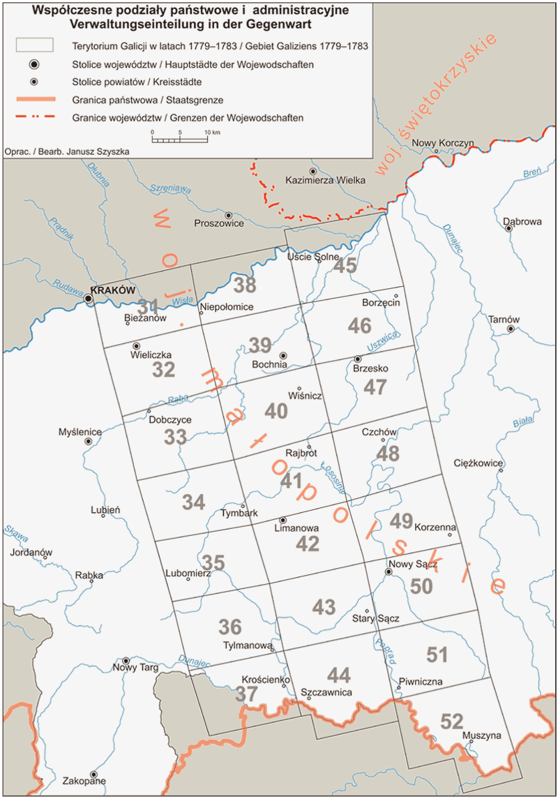
The volume encompasses: the Bocheńskie Foothills, the Wielickie Foothills, the Wiśnickie Foothills, the mountain range Beskid Wyspowy, the Sądecka Valley, the mountain ranges Gorce and Pieniny as well as the Beskid Sądecki mountain range. Almost the entire area stretched to the east from the line demarcated between Cracow and Nowy Targ was a part of the historical Cracow Voivodeship. There are important historical cities located in this area such as Wieliczka and Bochnia, the capital of the Sącz Land – Nowy Sącz, and further cities: Piwniczna, Muszyna, Limanowa, Nowy Wiśnicz, Brzesko and Niepołomice. This is also an area with an interesting natural environment, with the remains of the former Niepołomicka and Radłowska backwoods, large extensions of mountain forests (sometimes still primeval) and beautiful mountains which today are protected within the borders of the Pieniny National Park.
scope
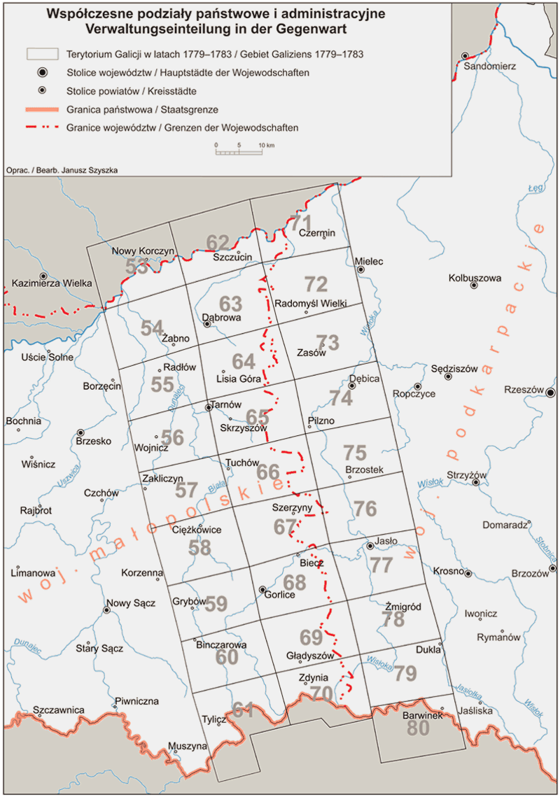
The volume encompasses the southern part of the Sandomierz Upland together with the Tarnów Plateau, further the Mid-Beskidy Foothills with a fragment of the Rożnów Foothills, the Ciężkowice Foothills and the Gorlice Lowering, and in the southern part – the Low Beskid mountain range. Interesting, in terms of nature, is the Magura National Park and other parts of the Low Beskid, also the Landcape parks among which the Ciężkowice-Rożnów Landscape Park and Ciśniańsko-Wetliński Natural Landscape Park. Located in this area are the historical cities of Tarnów and Biecz, also Dąbrowa Tarnowska, Dębica, Tuchów, Gorlice, Jasło and Dukla. In a large part this is the borderland zone of the Polish and Lemko settlements. After the partitions of Poland the northern part of the area covered by this volume was in the Tarnów District, and the southern part in the Dukla (Jasło) District. During the interwar period this territory was included into the Cracow Voivodeship (with the exception of some small land scraps in the south-east, which belonged to the Lwów Voivodeship). Presently the territory is located within the borders of the Lesser Poland Voivodeship, but the easternmost fragments belong already to the Subcarpathian Voivodeship.
scope
The volume encompasses the southern fragment of the Sandomierz Voivodeship (located beyond the Vistula River), a small, northern fragment of the Przemyśl Land with some important historical cities: Rzeszów, Łańcut, Przeworsk, Sokołów Małopolski, Leżajsk and Krzeszów, as well as the northern scrap of the Sanok Land which were part of the Old Polish Ruthenian Voivodeship. After 1772 this area was within the borders of the newly formed districts of: Tarnów, Rzeszów, Jasielsk, Sanok and Przemyśl. During the interwar period the area was included in its major part into the Lwów Voivodeship, while a small strand in the west was a part of the Cracow Voivodeship. Presently it is entirely encompassed by the borders of the Subcarpathian Voivodeship.
scope
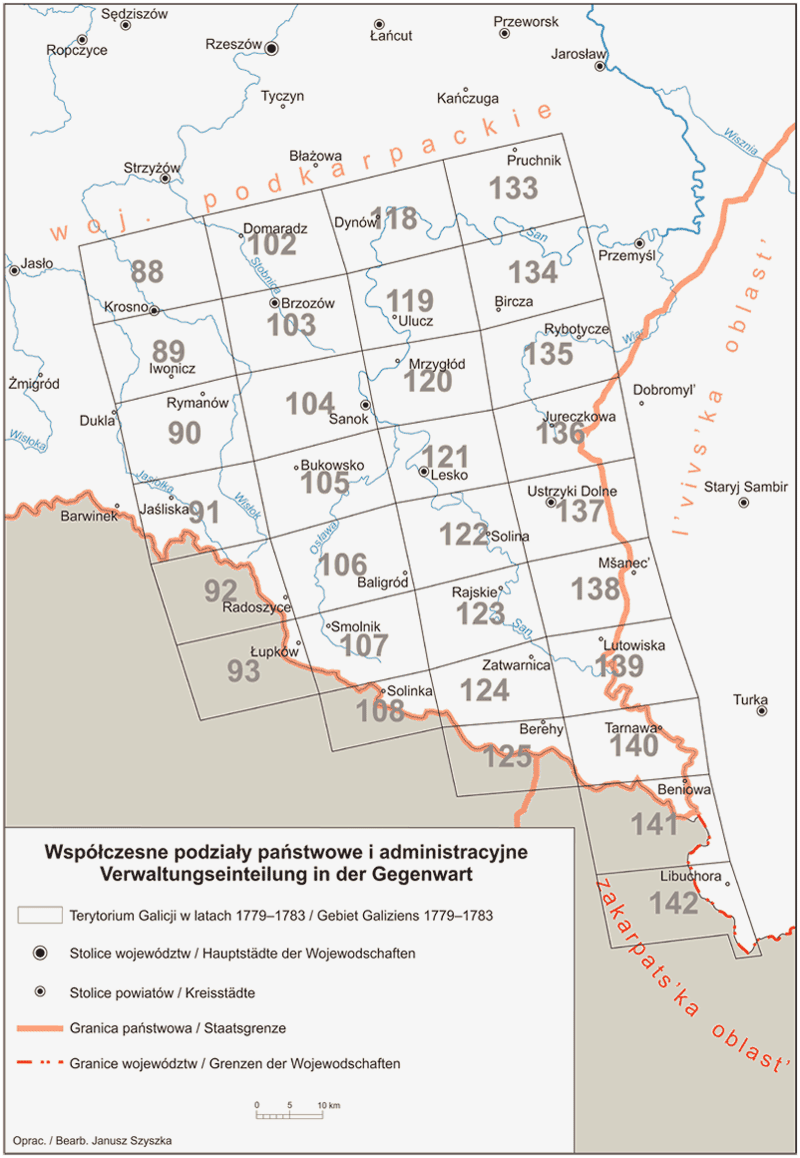
The volume encompasses almost the entire former Sanok Land and the western scrap of the Przemyśl Land which were part of the Red Ruthenia. Following the partitions of Poland this area formed the Sanok District. Geographically this is the western part of the Low Beskid mountain range, the eastern part of the Bieszczady Mountains and the Przemyśl Foothills. During the years 1918–1939 this entire area was included into the Lwów Voivodeship, while presently it remains within the borders of the Subcarpathian Voivodeship. Here we find the cities of the former Przemyśl Land such as Pruchnik, Bircza, Rybotycze, Ustrzyki Dolne as well as Sanok, Krosno, Brzozów, Dynów, Rymanów, Mrzygłód, Lesko, Baligród which formerly belonged to the Sanok Land.
scope
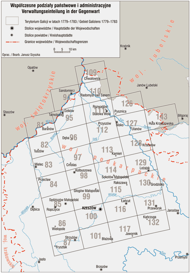
The volume includes 21 map sheets. The maps encompass a fragment of the historical Przemyśl Land from the Tanew River in the north to the line reaching west from the cities such as Sieniawa and Przemyśl. A fragment of the Bełz Voivodeship cuts into the land from the east. After the partitions of Poland the Districts of Przemyśl, Zamość and Żółkiew extended here. Before the Second World War the majority of this land belonged to the Lwów Voivodeship and the northern part of it to the Lublin Voivodeship. Today it is a part of the Sub-Carpathian Voivodeship, while the south-eastern fragments belong to Ukraine. Geographically it is a fragment of the Biłgoraj Plain, the Tarnogród Plateau, the Valley of the Lower San River and the Chyrów Plateau.
scope
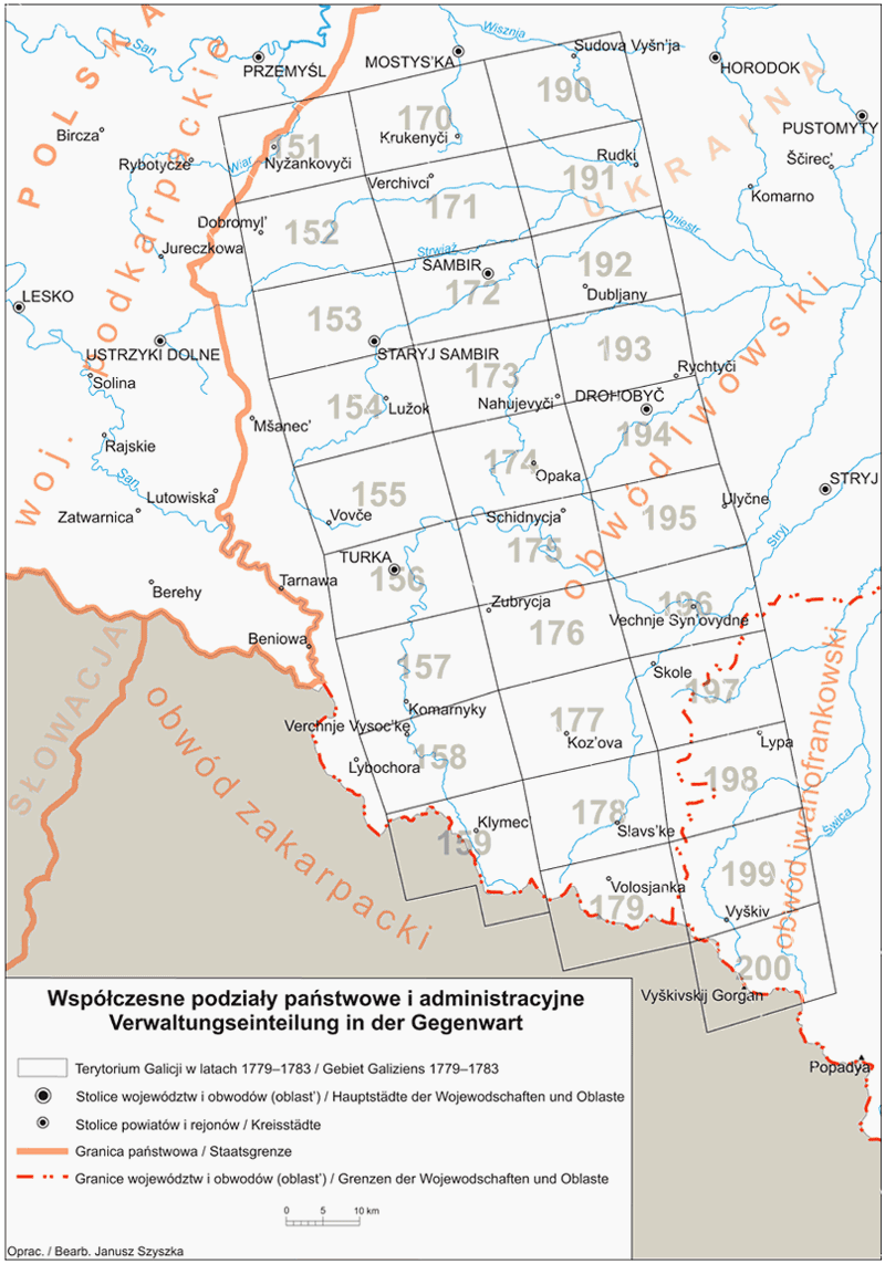
The volume contains 30 map sheets. They encompass the western fragment of the Ukrainian Carpathians and the Sub-Carpathian region. The northern, flat part, called the Pre-Carpathians, includes the Dniester River Plain, the Carpathian Foothills and a fragment of the San-Dniester Plateau. The southern, mountainous part of the region encompasses the Sanok-Turcza Mountains, a part of the Peripheral Carpathians, the Eastern Bieszczady Mountains and a fragment of the Western Bieszczady Mountains. From the 16th century till the time of the 1st partition this territory remained within the borders of the Polish state, being almost in its entirety the southern part of the vast Przemyśl Land and a small scrap of Lwów Land – both counted to the Ruthenian Voivodeship (Red Ruthenia). After the partitions they became a part of Austria as Przemyśl, Sambor and Stanisławów Districts. After the First World War they were parted in Poland between the Lwów and Stanisławów voivodeships.Presently they belong to Ukraine as a part of the Lviv Oblast and a small fragment of the Ivano-Frankivsk Oblast.
scope
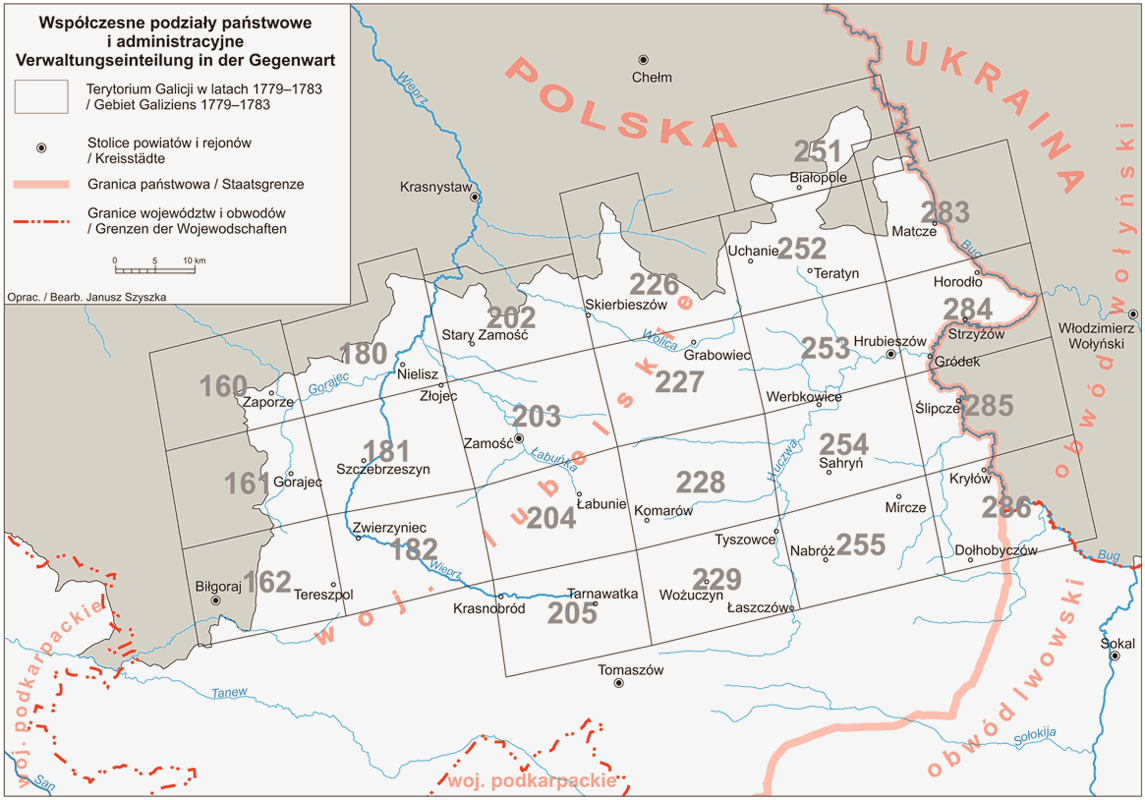
The volume encompasses parts of the former Bełz Voivodeship and the Chełm Land, which were included into the Red Ruthenia. After the partitions of Poland this area was the main part of the Zamość District. In physico-geographical terms it consists of parts of the Lublin Upland, the Roztocze mountain range, the Volhynia Upland and some scraps of the Volhynia Polesie in the north-east and the Bug River basin in the south east. The territories here represent some strongly varied settlement conditions: from the densely forested, mountainous Roztocze mountain range, which became colonized more intensively as late as the 15th–17th century, to the fertile, covered with black earth soils zone between Huczwa and Bug Rivers, which was well developed already in the early Middle Ages the strongholds: Cherven, Volhyn, Sutiejsk-Sąsiadka). Here we find the old cities: Horodło, Hrubieszów, Grabowiec, Szczebrzeszyn, Tyszowce and the main city of the region – Zamość. This naturally valuable zone between the upper Wieprz River and the middle Bug River is presently under protection within the borders of the Roztocze National Park and several Landscape Parks.
scope
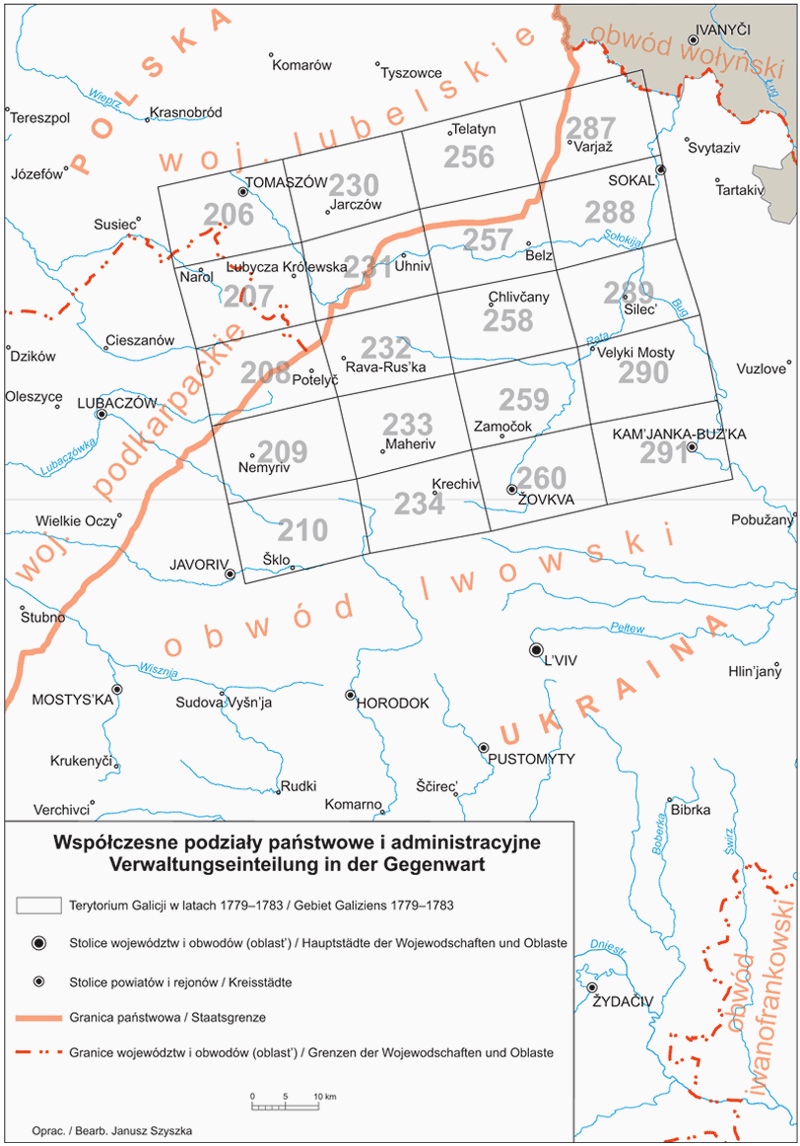
The volume includes 20 map sheets together with the corresponding military descriptions of the land. This material encompasses parts of the former Bełz Voivodeship and of the Lwów Land, both belonging to the Red Ruthenia. In this area located are the old centers which functioned from the time of the Middle Ages such as Bełz, Potylicz or Sokal, centers chartered in the 15th century: Kamionka Strumiłowa, Dobrotwór and Uhnów, as well as cities founded later, in the 16th –18th centuries, such as Waręż, Tomaszów, Rawa Ruska, Żółkiew, Krystynopol. After the partitions of Poland this area constituted the essential part of the Żółkiew District. Following the Second World War it became divided by the newly set state border between Poland and the Soviet Union (1945). The border was changed in 1951. Presently it is a state border between Poland and Ukraine. Geographically this zone stretches between the Roztocze mountain range and the Bug River, having the Bełz Plain in its center.
scope
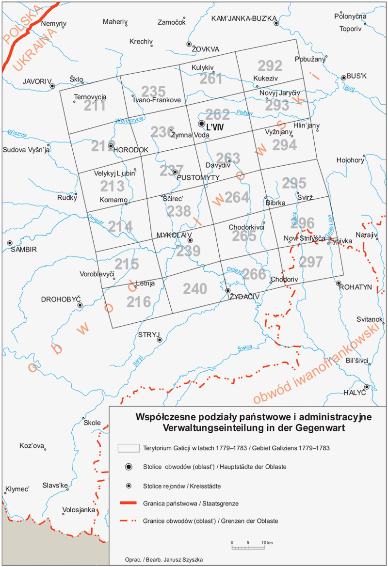
The volume includes 24 map sheets together with the corresponding military descriptions of the land. This material encompasses the core of the former Lwów Land and the eastern scrap of the Przemyśl Land which were part of Red Ruthenia, a province belonging to the Kingdom of Poland. There are old centres in this area that functioned from the time of the Middle Ages such as Lwów, Gródek or Żydaczów, which were towns chartered under Magdeburg law in the 14th century. After the partitions of Poland this area constituted the essential part of the Lwów (Lemberg) District as well as part of the Brzeżany and Sambor Districts. During the interwar period the area was included in its major part into the Lwów Voivodeship, while a small strands were a part of the Tarnopol and Stanisławów voivodeships. Presently it belongs to Ukraine as a part of the Lviv Oblast, and a small part lies within the boundaries of the Ivano-Frankivsk Oblast.
scope
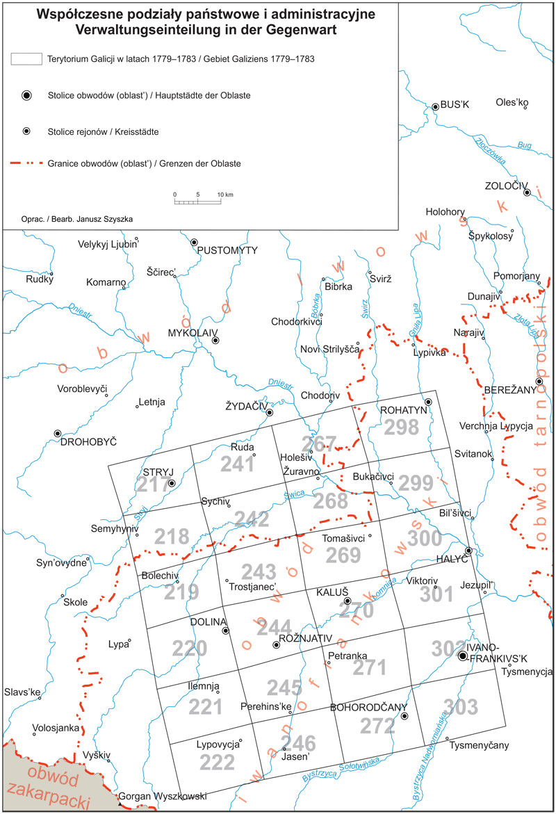
The volume contains 24 map sheets with the corresponding military descriptions of the country. Their scope includes the areas from the middle Dniester to the Carpathians. These form a quadrangle, in the corners of which lie the cities of Stryj, Rohatyn and Stanisławów (Ivano-Frankivsk) and the Gorgany chain. Until the First Partition of Poland (1772), these areas belonged to the Ruthenian Voivodeship and formed the southern part of the Lviv Land (Żydaczów District) and the western part of the Halicz Land. Only the northwestern strip belonged to the Przemyśler Land. Under Austrian rule, the majority of this territory was in Stryj Ditrict, while smaller fragments were in Brzeżany and Stanisławów Districts. In independent Poland, these territories came almost entirely under the Stanisławów Voivodeship. According to the current administrative division of Ukraine, this area is located within the borders of Ivano-Frankivsk and L'viv Oblasts.
scope
The material included in the volume encompasses the south-western parts of the Vohynian Uplands and the Little Polesie, both located east of the Bug River, and the north-western edge of the Podole Upland, together with the mountain ranges Woroniaki and Gołogóry. In the administrative terms, until the 1st partition of Poland this area constituted the south-eastern part of the Bełz Voivodeship and the north-eastern outskirts of the Lwów and Halicz Lands, both regarded as parts of the Ruthenian Voivodeship (Red Ruthenia). Following the partitions this area was mostly a part of the Zamość District, and constituted small parts of the Brzeżany, Tarnopol and Żółkiew Districts; during the Second Polish Republic it was located in the Lwów and Tarnopol voivodeships; presently it lies within the borders of the Ukrainian state (the Lviv and Ternopil Oblasts). Its cultural, administrative and economic landscape was marked by the bigger cities of the region: the early medieval Busk, but stronger by Brody, Brzeżany and Pomorzany – all chartered during the Polish times – and particularly by Złoczów.
scope
The volume contains 28 map sheets with the corresponding military descriptions of the terrain. The area described in this volume covers the western part of the Podolian plateau, extending to the foot of the Gołogóry and Woroniaki in the north and reaching the edge of the Opole plateau in the west. In the south-western corner, the area extends to the edge of the Carpathian foothills. Historically, this area remained within the borders of the Polish state until the First Partition of Poland, and the majority of it formed the north-eastern part of Halicz Land and the eastern edge of Lwów Land, which belonged to Ruthenian Voivodeship, as well as the western fragment of Podolian Voivodeship. In the period of the partitions of Poland, this area was part of the districts of Brzeżany, Tarnopol, Stanisławów and Zaleszczyki. In the interwar period, the larger part belonged to the Tarnopol Voivodeship, the smaller part to the Stanisławów Voivodeship, which today form two Oblasts based in Ternopil and lvano-Frankivsk (Stanisławów).
scope
The volume contains 46 map sheets (as well as five copies) with the corresponding military descriptions of the country. Three lands were in its area: Pokutia, part of the Eastern Carpathians and a small strip of Podolia. Until the First Partition of Poland (1772), these lands belonged to the Ruthenian Voivodeship (Red Ruthenia) and formed the southern part of the Halicz Land. Only the eastern strip belonged to the voivodeship of Podolia. Under Austrian rule, the majority of this area was in the Stanislau district, while smaller fragments were in the Zaleszczyki and Stryj districts. In independent Poland, these territories came almost entirely under the Stanisławów Voivodeship, with the exception of the eastern end, which belongs to the Tarnopol Voivodeship. According to the current administrative division of Ukraine, this region is located within the borders of Ivano-Frankivsk Oblast and Ternopil Oblast.
scope
The volume contains 28 map sheets with the corresponding military descriptions of the country. The sheets cover the western part of the Podolian plateau, which lies between the valleys of the two left-bank tributaries of the Dniester, the Seret in the west and the Zbrucz in the east. From the geographical-historical point of view, this area remained within the borders of the Polish state until the First Partition of Poland (1772) and formed the majority of the northeastern part of the Halicz Land of the Ruthenian Voivodeship and the western part of the Podolian Voivodeship (Royal Podolia). Its northern edges belonged to the Volhynian Voivodeship. In the partition period this area belonged to Tarnopol and Zaleszczyki counties, and in the interwar period to Tarnopol Voivodeship. Today, this area is located in Oblast Ternopil.
scope
Orders for the volumes 1 and 4 are processed by the publishing house Wydawnictwo Antykwa.
Orders for all other volumes are processed by the publishing house Wydawnictwo Towarzystwa Naukowego „Societas Vistulana” and by bookshop Księgarnia Instytutu Archeologii i Etnologii PAN.
The books are also sold by other scientific bookshops.
Type the name in the search box or zoom in on the map, then click on the location you are looking for to view the volume and sheet numbers of the Josephine land survey.
Website of the project
The Edition of the handwritten map of Galicia (so called “Mieg map”) from the years 1779–1783 – part II
realized in the years 2015–2022 as part of the „National Programme for the Development of the Humanities” established by the Minister of Science and Higher Education of the Republic of Poland
© 2016–2022 text and project by Andrzej Janeczek, Warszawa, Instytut Archeologii i Etnologii PAN
© 2019 German translation by Isabel Röskau-Rydel, Uniwersytet Pedagogiczny w Krakowie
© 2019 English translation by Beata Kita, Warszawa, Instytut Archeologii i Etnologii PAN

 Polski
 Deutsch
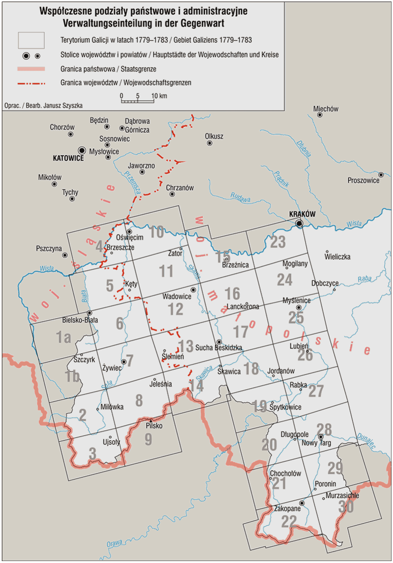